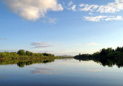
Vetluga (river)
Appearance
| Vetluga | |
|---|---|
 | |
 | |
| Native name | Ветлуга (Russian) |
| Location | |
| Country | Russia |
| Physical characteristics | |
| Mouth | Volga |
• coordinates | 56°27′44″N 46°14′14″E / 56.46222°N 46.23722°E |
| Length | 889 km (552 mi) |
| Basin size | 39,400 km2 (15,200 sq mi) |
| Discharge | |
| • average | 255 m3/s (9,000 cu ft/s) |
| Basin features | |
| Progression | Volga→ Caspian Sea |
The Vetluga (Russian: Ветлу́га, IPA: [vʲɪtˈlugə]; Mari: Вӱтла, romanized: Vütla) is a river that flows through Kirov Oblast, Kostroma Oblast, Mari El and Nizhny Novgorod Oblast in Russia. It is a left tributary of the Volga.[1] Their confluence is near Kozmodemyansk. The river is navigable. It is 889 kilometres (552 mi) long, and has a drainage basin of 39,400 square kilometres (15,200 sq mi).[1] Its largest tributaries are Neya, Bolshaya Kaksha, Usta and Yuronga from the left and Vokhma and Lyunda from the right.[1] The town Vetluga is situated on the river and named after it.
References
[edit]

